


Evaluation Area Map
Click on map to view it larger
The Chipuxet River begins in North Kingstown, RI and flows through agricultural fields and two impoundments. The river segment proposed for the Wild and Scenic Study starts just south of Route 138 in South Kingstown. It is a natural pond, not dammed, that is likely the remnants of a large kettle hole. From there the river flows under Route 138 at a popular river access point called Taylor’s Landing. There is a USGS stream gauge at this site. Once it leaves Taylor’s Landing there is no access to the Chipuxet River for 4 miles until it empties into Worden Pond. Along this stretch, the river slowly winds through the Great Swamp Management Area, at times becoming part of the large complex wetland. With almost no gradient changes, the river flow is languid and slowed even more by large areas of wetland vegetation.
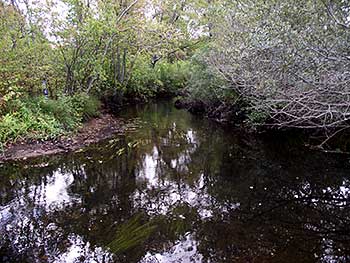
Chipuxet River at Liberty Lane. WPWA photo.
The Chipuxet River watershed collects precipitation from 36.9 square miles. It stores the water in sand below the surface and feeds the river. The river is fed by groundwater and is therefore considered a “gaining” stream. This means that under natural conditions streamflow is replenished from water seeping out of the ground from stored rainfall. Rain and melted snow collect between grains of sand and gravel. These subsoil products were deposited into the ancient Chipuxet River valley by glacial melt-water more than 10,000 years ago. This source has kept the river flowing ever since.
Water quality remains high due to protected lands and lack of development and accessibility. However, there are threats to the Chipuxet River due to multiple sites of water withdrawals. North of Thirty Acre Pond are expansive agricultural fields, primarily turf, that use water either directly from the river or from retention ponds to irrigate fields. Also, this area includes public water supply wells that provide all the drinking water for the University of Rhode Island and Kingston village. Just south of Taylor’s Landing are two more points of water withdrawal for agricultural irrigation.
Outstandingly Remarkable Values
Ecology – The entire three miles of the Chipuxet River, from Taylor’s Landing to Worden Pond is undeveloped. This stream is an integral component of the Great Swamp, the largest swamp in the region. Filled with a large variety of wetland plants, the habitat supports many aquatic dependent species of invertebrates, birds, mammals, amphibians and reptiles. The area is a National Natural Landmark.
Scenic/Recreation – The Chipuxet’s slow meander through three miles of wetlands provides beautiful scenery for paddlers; opportunities to fish and hunt; and observation of wildlife. The South County Bike Path crosses the Chipuxet, giving bikers and walkers a glimpse into a wild system.
Cultural – Rich agricultural fields are found on the outwash plains.